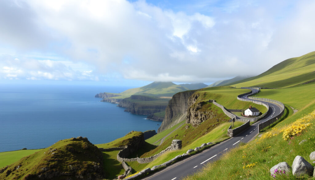
Ring of Kerry Images: Best Photo Stops & Driving Tips
There’s a reason the Ring of Kerry is one of the most photographed routes in Ireland: it packs mountains, lakes, coastline, and ancient ruins into a single 179 km loop. Whether you’re hunting for that iconic Ladies View shot or wondering where to find free images of the Skellig Islands, this guide covers the best photo stops, practical driving tips, and honest comparisons to help you plan your trip.
Total distance: 179 km (111 miles) ·
Driving time (no stops): 3.5–4 hours ·
Recommended with stops: Full day (8–12 hours) ·
Start/end point: Killarney town ·
Highest point: Coomakista Pass (230 m / 755 ft)
Quick snapshot
- The Ring of Kerry is a 179 km circular route in County Kerry (The Irish Road Trip (travel guide))
- It passes through Killarney National Park (Irish Experience Tours (tour operator))
- The route includes views of the Skellig Islands on clear days (Irish Experience Tours (tour operator))
- Traffic is heaviest in summer between June and August (The Irish Road Trip (travel guide))
- Exact number of annual visitors – no official count published as of 2024
- Whether free image downloads are copyright-free – always verify license terms
- Whether the Skellig Ring detour is worth the extra time depends on weather conditions
- Whether the Kerry Cliffs’ drop is exactly 1,000 feet is not independently verified
- Driving without stops: approximately 3.5 hours (Overland Ireland Tours (tour operator))
- With stops and lunch: 7–8 hours (In Between Travels (travel blog))
- Summer months bring heavier traffic; start by 8 a.m. recommended (The Irish Road Trip (travel guide))
- Consider the Skellig Ring detour – less traveled and often called the most scenic part of the drive (Irish Experience Tours (tour operator))
- Check weather forecast before heading out – mist can obscure views (Irish Experience Tours (tour operator))
- Review free image sources (Flickr, Tourism Ireland media library) for editorial use (Irish Experience Tours (tour operator))
For a quick overview of the route’s essential statistics, see the table below.
| Fact | Detail |
|---|---|
| Route length | 179 km (111 miles) – circular route |
| Driving time (minimum) | 3.5–4 hours |
| Time with photo stops | 8–12 hours |
| Primary language | English, Irish (Gaeilge) |
| County | County Kerry, Ireland |
| Nearest international airport | Kerry Airport (KIR) – 20 minutes from Killarney |
What is the most beautiful part of the Ring of Kerry?
If you’re after picture-postcard shots, four spots stand out above the rest. Each offers a different angle on the route’s landscape — mountain passes, lake reflections, ancient stone, and Atlantic views.
Ladies View viewpoint
- The story: Named after Queen Victoria’s ladies-in-waiting who admired the panorama in 1861, Ladies View offers a sweeping vista of the lakes of Killarney and the surrounding mountains (Roaming Required (travel blog)).
- Photo tip: Visit in the late afternoon for soft light on the lakes.
Moll’s Gap and the Black Valley
- This mountain pass sits 260 m above sea level and looks out over the Black Valley and Ireland’s highest mountain range, the MacGillycuddy’s Reeks (The Creative Adventurer (travel blog)).
- There’s a designated pull-off area for photos.
Killarney National Park lakes
- The park borders the route and offers multiple lake viewpoints, including the famed Torc Waterfall (Ireland.com (official tourism site)).
- A short walk from the road leads to the waterfall – a favourite among photographers.
Skellig Michael view from the road
- On clear days, the Skellig Islands are visible from the western section of the route, particularly near the Kerry Cliffs (The Irish Road Trip (travel guide)).
- The Kerry Cliffs themselves drop 1,000 feet into the Atlantic (Irish Experience Tours (tour operator)).
For a photographer, Ladies View and Moll’s Gap are non-negotiable. The Kerrys’ coastline at the Kerry Cliffs gives you the drama of Skellig without the boat ride. Plan your schedule around these three – they’re the backbone of any Ring of Kerry image library.
These three locations are the top priority for any photographer visiting the Ring of Kerry.
What is special about the Ring of Kerry?
The route isn’t just a pretty drive – it threads through a UNESCO-recognised geopark, past iron-age forts, and into villages where traditional music still plays nightly.
UNESCO Global Geopark status (Kerry Geopark)
- The Ring of Kerry passes through the Kerry Geopark, part of the UNESCO Global Geoparks network (Ireland.com (official tourism site)).
- The geopark preserves 480 million years of geological history, visible in the rock formations along the coast.
Ancient monastic sites and ring forts
- Staigue Fort – one of the best-preserved ring forts in Ireland – lies a short detour off the main route (The Irish Road Trip (travel guide)).
- The fort dates from around 300–400 AD and is open to the public free of charge.
Traditional Irish music and pubs along the route
- Towns like Sneem, Waterville, and Kenmare host regular live music sessions, especially in summer (Irish Experience Tours (tour operator)).
- Many pubs have been serving travellers for over a century – a cultural layer that adds depth to any image set.
The Ring of Kerry’s appeal is multi-layered: geology, archaeology, and living culture combine in one loop. For the visitor, that means every pull-off has a story – and that story makes your photographs more than just landscape shots.
This cultural and geological depth makes the route more than just a scenic drive.
Which is better, Cliffs of Moher or Ring of Kerry?
Both are headline Irish attractions, but they serve different needs. The table below lays out the key differences for a photographer choosing between the two.
| Factor | Cliffs of Moher | Ring of Kerry |
|---|---|---|
| Duration needed | 2–3 hours | Full day (8–12 hours) |
| Landscape diversity | Single dramatic cliff face (8 km) | Mountains, lakes, coastline, forests, villages |
| Entry fee | €12 adult (2024) | Free – public road |
| Best for photographers | One iconic wide-angle shot | Multiple subjects: seascapes, reflections, ruins, wildlife |
| Crowds | Very busy in peak hours | Heavy on main route but easier to escape via detours |
| Accessibility | Paved paths, visitor centre | Road with pull-offs; some stops require short walks |
The pattern is clear: if you have half a day and want a single dramatic shot, choose the Cliffs. If you have a full day and want a portfolio of images, the Ring of Kerry wins hands down.
For travellers doing both: visit the Cliffs first (shorter commitment), then dedicate a full day to the Ring of Kerry. Trying to combine them in one day means rushing the Ring and missing its best light.
The choice depends on how much time you have, but the Ring of Kerry offers more variety.
How long does it take to drive around the Ring of Kerry?
This is the most common question, and the answer depends entirely on how many times you pull over for a shot.
Minimum driving time without stops
- The 179 km loop can be driven in approximately 3.5–4 hours (Overland Ireland Tours (tour operator)).
- This assumes no traffic delays and no photo stops – unrealistic for most visitors.
Recommended time for photography and sightseeing
- Most guides recommend 8–12 hours to allow for photo stops, meals, and short walks (A Little Adrift (travel blog)).
- A detailed itinerary suggests 7–8 hours if you include the Skellig Ring detour, lunch, and the main photo stops (In Between Travels (travel blog)).
Best times of day to avoid traffic and catch good light
- Summer months (June–August) have heavier traffic; start by 8 a.m. to beat the tour buses (The Irish Road Trip (travel guide)).
- Golden hour (early morning or late afternoon) provides the best light for landscape photography.
- Midday sun creates harsh shadows on mountain and lake scenes – aim for 9–11 a.m. or 4–7 p.m. for softer contrast.
Photographers should plan for a full day to capture the best images.
Where is the best place to start the Ring of Kerry?
Your starting point affects which side of the road the coastal views fall on and how much time you spend behind a tour bus.
Starting from Killarney town
- Most visitors start in Killarney and drive clockwise to keep the ocean views on the driver’s side (Travel Yes Please (travel blog)).
- Clockwise also lets you avoid many tour buses, which typically travel counter-clockwise (Irish Experience Tours (tour operator)).
- The route is well signposted from Killarney; no special permits are needed.
Alternate start: Kenmare (south)
- Starting from Kenmare is recommended for those staying in south Kerry (The Irish Road Trip (travel guide)).
- Going clockwise from Kenmare means you’ll hit the most scenic mountain passes in the afternoon light.
Driving direction: clockwise vs counter-clockwise
- Clockwise: ocean views on the left, easier pull-offs, less bus traffic.
- Counter-clockwise: ocean on the passenger side, but may require more manoeuvring for photo stops.
- A guide recommends clockwise specifically to avoid tour buses (Irish Experience Tours (tour operator)).
Narrow roads and sharp bends are common. If you’re a solo photographer, the clockwise direction gives you safer stopping options. A full tank of fuel and a paper map (mobile signal can drop) will save your day.
Choosing the right starting point and direction can significantly affect your photo opportunities.
Step-by-step: planning your Ring of Kerry photo drive
Follow these five steps to maximize your shooting time and minimise stress.
- Start early (before 8 a.m.) – Beat the tour buses and catch soft morning light on the lakes (The Irish Road Trip (travel guide)).
- Choose clockwise from Killarney – Keeps ocean views on the driver’s side and reduces bus encounters (Irish Experience Tours (tour operator)).
- Plan 5–6 photo stops – Ladies View, Moll’s Gap, Derrynane Beach, Kerry Cliffs, Torc Waterfall, and Staigue Fort are the top picks (Ireland.com (official tourism site)).
- Allow extra time for detours – The Skellig Ring adds 1–2 hours but delivers the most dramatic coastal images (In Between Travels (travel blog)).
- Check weather and light – Mist can obscure mountain views; clear Atlantic air gives the sharpest photos. Use apps like Met Éireann for forecast.
Following these steps will help you maximize your time and light.
What we know for sure – and what’s still uncertain
Confirmed facts
- The Ring of Kerry is a 179 km circular route in County Kerry (The Irish Road Trip (travel guide))
- It passes through Killarney National Park (Irish Experience Tours (tour operator))
- The route includes views of the Skellig Islands on clear days (Ireland.com (official tourism site))
- Traffic is heaviest in summer between June and August (The Irish Road Trip (travel guide))
What’s unclear
- Exact number of visitors per year (no official count published as of 2024)
- Whether free image downloads are copyright-free – always verify license terms
- Whether the Skellig Ring detour is worth the extra time depends on weather conditions
- Whether the Kerry Cliffs’ drop is exactly 1,000 feet is not independently verified
This overview helps set realistic expectations for your trip.
What the experts say
The Ring of Kerry offers a diverse landscape of mountains, lakes, and coast that makes it one of Ireland’s premier scenic driving routes.
Failte Ireland (Ireland’s National Tourism Development Authority)
The Kerry Geopark showcases 480 million years of geological history – a timeline written in rock that visitors can see from the road.
Kerry Geopark (UNESCO Global Geopark network)
Starting clockwise from Killarney is the smartest move for photographers – the light hits the lakes and mountains at the right angle for most of the morning.
Irish Experience Tours (tour operator)
The consensus across these sources is clear: the Ring of Kerry demands a full-day commitment, rewards those who start early, and delivers photographic variety that few other Irish routes can match.
Frequently asked questions
Is it worth driving the Ring of Kerry in one day?
Yes – most visitors complete the loop in a single day. Allow 8–12 hours for photo stops and meals. It’s a long but rewarding day.
What is the best time of year to drive the Ring of Kerry?
Late spring (May–June) and early autumn (September) offer mild weather, fewer crowds, and good light. Summer is busiest; winter days are short and often misty.
Can I take a bus tour on the Ring of Kerry?
Yes – several tour companies operate day trips from Killarney. You sacrifice flexibility but gain a narrated experience and don’t have to drive the narrow roads.
Are there toll roads on the Ring of Kerry?
No – the entire route is a public road with no tolls. Parking at most viewpoints is free, though some car parks near attractions may charge.
What should I pack for a Ring of Kerry drive?
Bring a camera with a wide-angle lens, rain cover, snacks, water, a full tank of fuel, and a paper map. Mobile signal can be patchy in the mountains.
Is the Ring of Kerry suitable for electric vehicles?
Yes – there are charging points in Killarney, Kenmare, and Caherciveen. But range anxiety is possible given the 179 km loop and limited chargers along the route.
Are pets allowed on the Ring of Kerry?
Pets are allowed in the car and at outdoor stops. Some beaches and national park trails have restrictions – check local signs.
This guide provides everything you need to plan your photo drive.
More related posts
 Volkswagen ID.4 for Sale in Ireland: Prices & Deals
 Tom Ford Tobacco Vanille: Scent, Price & FAQs
 Puppies for Sale in Ireland: Prices, Breeders & Laws
 December 10 Band Members – Roster, History and Key Facts
 What Does PS Stand For? Text, Slang, Gaming & More
 Malahide Castle Concert Capacity: 20,000 – Seating, Times & Layout
 Trump News Now Live: Latest Updates & Press Conference Today
 HSE Organ Donation Opt Out: How to Register in Ireland
